OsmAnd Guide & App Test! OsmAnd is the most popular open-source maps and navigation app for Android.
The feature set is huge: complete offline navigation, offline maps and GPX import are interesting features. Whether OsmAnd is suitable as a bicycle navigation system, what is good and where the weaknesses are, you will find out in this OsmAnd test. Offline Android Navigation!

OsmAnd – the best features
The following functions are the highlights of OsmAnd:
Completely offline – The app works after map download completely without internet
✅ offline maps, offline tour planning, offline navigation
Worldwide offline map material
GPX file import for example for already planned tours
Difference: OsmAnd vs OsmAnd+
OsmAnd Plus or OsmAnd? Where are the differences? You can download the app for offline Android navigation for free from the Google Play Store. You can also buy OsmAnd+ on Google Play:
What is the difference between OsmAnd and OsmAnd+? The biggest difference is in the offline maps:
- OsmAnd: limited number of offline maps storable.
- OsmAnd+: Unlimited number of offline maps storable.
OsmAnd+highly priced by app standards. For the range of functions offered, the price is more than fair. This is a one-time purchase and not a subscription. Super!
With OsmAnd Live there are now also some features that are only available by subscription.
Functions and menus
OsmAnd has a huge feature set. To keep the article clear for you, I explain the best features and bike functions:
- Navigation to the destination (destination navigation)
- Navigation with pre-planned GPX track
- Weitere Highlights 😉
OsmAnd has many features and gives you a lot of freedom. Accordingly, the operation is also more complex than with a App such as komoot. Are you understood OsmAnd, you should first learn. As I said, don’t worry: I’ll introduce you to the most important features in the OsmAnd guide.

Launch OsmAnd and you will be taken directly to the overview page. Open the menu (three dashes on the bottom left): From here you have direct access to your favorites, search, navigation, the map management (for offline navigation) and more. I find the menu a bit cluttered but it can also be customized.
Start navigation:
- Go back to the map view
- Tap on the arrow button at the bottom left – in this view you can start navigation
OsmAnd cards explained
Tap “Map Management” in the menu (three stitches down on the left).

Here you can download and update OsmAnd maps – worldwide overview maps can also be downloaded. You can also download language packs for voice prompts and fonts.
Also available for download: contour lines, relief and additional info packages from Wikipedia.
OsmAnd uses only maps from the free OpenStreetMap Project (OSM).
There is also a setting to disable online access for the maps. This will prevent you from reloading map sharing and OsmAnd really works completely offline (insert instructions).
OsmAnd guide for complete offline navigation:
You want to make sure that OsmAnd doesn’t consume traffic and really works completely offline?
proceed as follows:
- Open the menu (three dashes in the lower left corner)
- Type “Configure Map”
- Type “Map source…”
- Select “Offline vector maps”

Configure card” menu
You can set the display of the map in great detail. I will show you the most important functions:
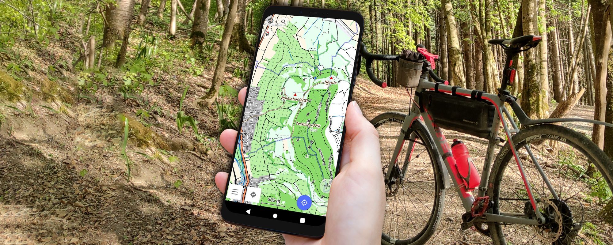
- Map display: Tour view, Topo, Offroad. As you can see, the display of the map changes a lot. You can use it to change the view to suit your current sport.

If, for example, you travel a lot off-road with a mountain bike or gravel bike, then the off-road map with a high contrast is ideal. In the submenu “Map display” many more settings can be made. For many helpful is certainly the adjustability of the font size. A simple setting with great effect 😉
POIs: If you want to display POIs such as restaurants and shops, this is possible with the option “Show POI overlay”.
Elevation lines: Also useful in terrain are elevation lines that can be activated and deactivated. You can also configure the height lines and thus determine, for example, the width of the height lines and the zoom level at which the height lines are displayed. For even more fine tuning with the contour lines, there is a module to buy separately: “Contour Line Module and Relief”.
Wikipedia: The “Wikipedia” option embeds Wikipedia articles in relevant locations on the map and displays them on demand. This option is quite useful for tourist trips and requires a data connection. With offline navigation only, it is not possible to retrieve Wikipedia articles.

Offline navigation with bike
With OsmAnd a complete offline navigation is possible:
- The OsmAnd cards are available in the memory of your smartphone
- The route is calculated entirely locally on your smartphone
OsmAnd navigation profiles: What kind of route is calculated is determined by the navigation profiles. You can configure the navigation profiles as follows:
- Open the menu (three dashes at the bottom left) and tap on “Navigation”. In this menu you can now start the navigation. At the same time, your activated navigation profiles are displayed at the top of the screen.
- Tap the three dots in the top right corner to enter the App Profiles menu.
In this menu you will see the already existing profiles. OsmAnd handles a variety of navigation profiles (called app profiles). OsmAnd already comes with default profiles. You can change these standard profiles as you wish. You can also create your own profiles to suit your own needs.
The following navigation profiles are already provided by OsmAnd:
- Car
- Bicycle
- Pedestrian
- public transport
- Boat
- Airplane
- Skiing

With the slider you can activate and deactivate navigation profiles, by tapping a navigation profile you get to the menu “Configure profile”and with “Manage” you can create new profiles. Now you can, for example, create new profiles for the route calculation of road bike or mountain bike routes.

The menu item “Route parameters” is particularly interesting. This is how you reach this menu:
- Tap on an existing profile or tap “Manage” to create a new profile
- Select “Navigation Settings”
- Select “Route Parameters”

In this menu you can make settings for route planning.
For example, you may prefer unpaved roads or choose the shortest route. Also, certain roads can be avoided. For example, road cyclists can deactivate cobblestone or paved roads for route calculation.
OsmAnd tour planning
The Osman tour planner is rather awkwardly solved. Tour planning takes a long time and is significantly more complex than, for example, the other outdoor route planners like komoot.
Door planning can be started in several ways:
Via the menu (three dashes at the bottom left)and the menu item “Navigation”. There you have several options to choose the start and destination point. More on that in a moment.
Alternatively, you can set the navigation destination directly on the map. To do this, simply long-tap on a point on the map until a navi pin appears. Now tap “Navigation” on the bottom right. The selected point on the map is now set as the destination point.
Profiles for route calculation can be selected in the navigation screen. In addition, basic information about the route is displayed: Distance, time and the altitude profile.
With the + symbol you can add an intermediate destination. The starting point can now also be determined. To choose a location, there are also many options. The most likely way to search is by entering the location or selecting the location on the map.

Once you have selected the waypoint, it will be displayed as “Waypoint (1)” in the navigation menu. The calculated route is also adjusted on the map.
Tap the pencil icon. In the Targets screen, you can now change the order of the targets. To do this, tap the handle icon and drag the target up or down. The X symbol removes the target. The buttons “Add” and “Delete all” are self-explanatory (if not: feel free to write me your comment 😉 ).

OsmAnd also offers extensive tour planning functions. It would be nice to have a desktop version of the app to be able to plan even more complex tours on the big computer screen. Also, fine-tuning the route by drag-and-drop on the map is unfortunately not possible.
GPX tracks with OsmAnd
GPX files can be easily imported to OsmAnd and used. OsmAnd’s GPX import features are strong:
Import GPX file to OsmAnd App
GPX import option 1: With Android file manager
- Select a GPX file in an Android file manager
- Tap on the file to open
- Jetzt erscheint das Menü “öffnen mit”
- select OsmAnd here

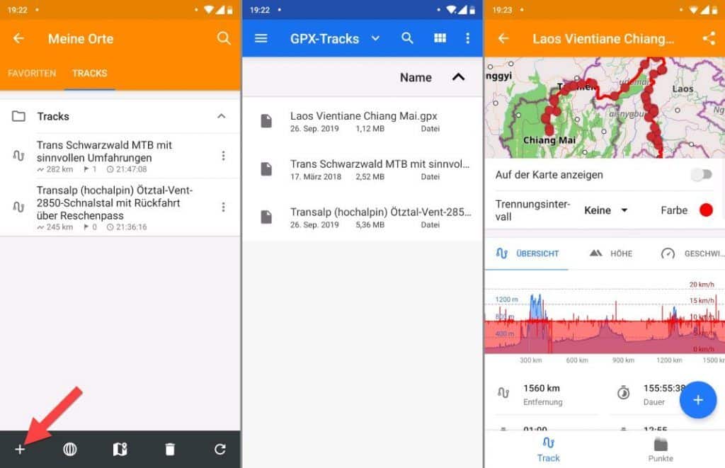
GPX import option 2: Directly in the OsmAnd app
- Open the sidebar
- tap “my places”
- change to “all tracks”
- tap on the Plus symbol in the bottom left corner
Using already imported GPX files in OsmAnd
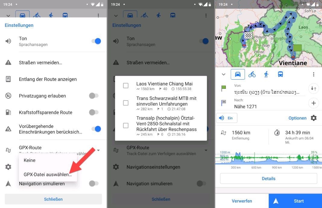
- Tap the navigation button on the bottom left, or open the sidebar by tapping the three dashes on the bottom left, then tap navigation.
- Tap on the gear icon with the text “Options”.
- In this in the settings you will find the menu item “GPX-Route”. Open this menu item
- Tap “Select GPX file” to load previously imported GPX files.

You loaded the GPX file? Super! Now tap “Start” on the bottom right to start navigation. A route to the starting point is calculated by OsmAnd. So OsmAnd navigates you to the starting point and along the selected GPS track.
If the loaded GPS track is too far away, OsmAnd shows you the way to the start as the crow flies.
Navigation with OsmAnd

Navigation with voice prompts
OsmAnd also handles voice prompts to assist with navigation. A function that can be very useful.
You can activate the voice prompt in the settings. There you can also adapt them to your wishes. This will take you to the settings and you can make the following adjustments:

The OsmAnd voice prompts are well implemented. I use it with almost every navigation with OsmAnd.
As always with outdoor navigation, a voice prompt is more of a request to look at your smartphone screen right now. Turns and trail conditions are very complex in the outdoor environment. Much more complex than car navigation on the road. That’s why you get lost even with the best voice prompts. As I said, looking at the display helps and OsmAnd does a good job with voice navigation.
Who is OsmAnd suitable for?
You have the highest demands on your bike navigation and want to be able to adjust every detail? You attach importance to completely offline navigation? You’re willing to learn a nav app for that?
Then OsmAnd is probably the right Android offline navigation app for you!
Osmand offers an enormous range of functions: Navigation to the destination (destination navigation) along self-planned routes and imported GPX files. Highly customisable voice prompts via smartphone speaker or connected Bluetooth devices. The range of functions is almost all-encompassing.
OsmAnd experiences
OsmAnd is one of the most powerful bike navigation apps for Android. The app has a wide range of functions and many setting options. Once you have mastered the app, however, some time will pass.
Personal conclusion
✅ OsmAnd has its strengths in offline navigation with the bike. OsmAnd+ can download as many maps as you want and reliably navigate directly to your destination. The convenient map management is easy to use and you can quickly download or update the right map: Android offline navigation can begin. Navigation along imported routes through GPX files works great. For these functions I can highly recommend OsmAnd.
The planning of routes in the app is convenient, but fine-tuning is only possible with difficulty. Also, there is no OsmAnd version for desktop computers, so you are limited to the relatively small screen on the smartphone. Other apps offer web clients, allowing complex planning to be done on the computer.
Alternatives to OsmAnd
Locus Map
Locus Map vs OsmAnd: Locus Map is similarly large in feature set. Compared to OsmAnd, Locus Map is easier for beginners. Once you have familiarized yourself with the app, you will discover more and more functions to adapt it to your own needs.
Learn more about Locus Map in the overview of the TOP 35 Bicycle Apps.
komoot
komoot follows a different approach than OsmAnd and is therefore an ideal alternative to OsmAnd: komoot is very beginner-friendly. The route planner is available for Android, iOS and for the web browser. With the route planner, even beginners can easily plan complex routes. The large computer screen can be used for this purpose. The planned routes are automatically synchronized with the smartphone. This can then be used for navigation. GPX files can also be exported and then imported into OsmAnd for further processing or navigation.
To the detailed komoot test (test & full instructions)
What do you think of OsmAnd for bike navigation and as a route planner? Do you have any questions? Feel free to write me your comment
Reading Tip: Looking for more inspiration and looking for the best bike apps? I’ll introduce you to these on the blog as well. There you will find the best bike apps & bike travel apps. The best apps in navigation, training, MTB, bike computers, transportation, accommodation, communication and more.


