
komoot test: With komoot you can plan your bike tour comfortably on your computer or smartphone and export the route to your GPS navigation. The komoot app offers convenient bike navigation on the go.
This article is a complete komoot guide. In this article you will learn:
✅ komoot route planner: Simply plan your next tour with komoot! You can also find exciting cycling tours in the database. I’ll explain all the functions of the komoot route planner step by step: Plan a tour directly with komoot.
✅ komoot Navigate: How komoot works as a bike navigator with the komoot app! I introduce you to all the displays and functions on the screen when navigating.
✅ komoot Offline Maps: This is how komoot offline maps work. Download maps and save data volume.
✅ connect komoot with Garmin, Wahoo and other bike computers
✅ import and export komoot GPX
✅ komoot Alternatives: Besides komoot, what apps are interesting for bike navigation?
You have a question about komoot and can’t find the answer in this article? Search best in the article with ctrl+f. I’m sure you’ll find the answer to your question. If not, feel free to drop me a comment & I’ll answer you 😉
The komoot platform consists of the website, the smartphone app and interfaces to GPS navigation devices. It offers convenient planning and navigation, as well as wireless data transmission. A tour diary is automatically created and a social network is integrated.
This komoot test is up to date: Based on my experience with the app version May 2020 (v 10.7.7)
The mobile phone is attached to the handlebars and komoot is installed: The outdoor mobile phone navigation can begin.
komoot Android App and komoot App for iPhone
You can download the komoot app free of charge for Android and iPhone. The download takes place from the known App Stores:


Before you can get started, you need to sign up. Without registration you cannot use komoot. The login options are the Facebook login or the login with email and password. Right out of the gate, you get a gift:
- A free komoot region: With this the download of this region and thus the offline navigation is possible.

The komoot complete package costs 30 €. You want to use komoot regularly and intensively for planning and bike navigation? Then the world package is worth it.
This greatly expands the functionality of the app. The komoot complete package includes all functions:
- worldwide komoot offline maps
- Voice output during navigation
For the performance offered, the price is more than fair. With the komoot world package you no longer have to worry about individual regions and restrictions.
At the bottom of the screen in the komoot app is the main navigation. The main navigation is divided into five sections. Thanks to the logical menu, you will get along immediately even without previous komoot experience:
- Discover: Tour suggestions can be found in this section. The tours are created by komoot, by users or sometimes by advertising partners. In the Discover menu you can let yourself be inspired. You can either follow the tours directly or use the Komoot route planner to adapt them to your ideas. Tip: You can also hide the Discover tab: Profile > Settings > App Settings > Show Discover area
- Planning: With the komoot route planner you can plan your own tours. The functions of the komoot route planner are presented in detail below.
- Record: Here you can start the GPS recording. The tour will then be saved in your profile as made tour. This is especially useful if you want to ride and record a known route without bike navigation. A look at the map is possible at any time during the journey.
- Profile: The main features in this menu are access to your planned tours and made tours. In the profile you also have access to the komoot app settings, your statistics and your highlights (favorites).
- More: Here you can buy regions and save them offline. You can also unlock the world package directly and have access to komoot Premium (I’ll explain the features below).

[the_ad id=“6449″]
Komoot free, pay or komoot premium?
Free of charge there is a region at komoot. Can you use komoot for free and the komoot test is also available for unlimited time. What’s the deal with regions? What are my experiences with komoot Premium?
These komoot functions are chargeable:
- Save komoot offline maps to smartphone: komoot maps can be downloaded to your smartphone. To do this, you must have unlocked the region in which the tour starts. With the komoot world package you own all regions.
- komoot voice navigation: You want to receive voice hints from komoot when navigating? Then the start region of a route must also be activated.
How extensive is the free komoot tour planning? Can I use komoot for free if I only want to use the komoot trip planner?
- Free komoot route planner: Even in the free version you can access all the functions of the komoot route planner.
- GPX Download: Would you like to download the planned tour as a GPX file for your GPS navigation device? You can only do this if you have bought the start region of the tour. Below you will learn how to easily use your planned tour on your smartphone or on your GPS bike navigation system.
- Use komoot on Garmin and Wahoo bike computers: The same restriction exists for the interface to GPS bike computers, for example from Wahoo, to Garmin Connect IQ Navis etc.. Activities can only be transferred if you have purchased the region in which the activity starts.

In summary: komoot free trial is possible. You only want to use the komoot app on your smartphone and don’t need offline navigation? Besides, don’t you need voice prompts? In this case you can use komoot for free as long as you want.
If you want to use the bike navigation app seriously, then buy the world package for 30 €. Then you don’t have to worry about region boundaries anymore. You can then relax and use komoot for bicycle navigation in everyday life, on vacation or on bicycle trips. For the price you get worldwide offline bike navigation and voice prompts during navigation. It is then also possible to download GPS and use the interfaces to GPS bicycle navigation systems.
Tip: sometimes there are komoot coupon codes for a free region. Sometimes you can get the complete world package for 20 € with a code. But also the normal price of 30 € is very fair.
What is komoot Premium?
follows 😉
komoot navigation in the komoot test
You want to start a simple navigation with komoot without planning a tour with komoot for a long time? You can either select a location on the map or specify the destination by entering the address. I’ll show you both options:
Navi Determine destination on the map – fast navigation
- In the main navigation at the bottom of the screen, select the Planning section.
- Tap briefly on the map – now the map is displayed full screen
- Find your destination on the map and hold your finger long on the destination.
- Now a menu appears: Tap here . As a destination.
- Then select your sport and you can already start the navigation

Tip: The calculated route will be adjusted according to your sport. So if you have chosen mountain biking, komoot will suggest a different route than if you choose road biking.
Komoot is also expanding the types of sports available. On this page you will find the sports for the komoot route planner. Currently komoot is planning routes for:
- Cycling
- Mountain bike
- Road cycling
- Cycling (with gravel)
- Mountain biking (alpine)
- Hiking
- Run
- Mountaineering
Practical tip – own komoot experiences: test komoot with different sports is worthwhile: Often, for example, interesting routes are created with the mountain bike profile, which you can ride with the gravel bike. Or you can have a „cycling (with gravel)“ route created and ride the route on a touring bike. Often works but not always.
Navi Determine destination by entering address – komoot Navigation
- In the main navigation at the bottom, select the Plan section.
- Tap Select a destination.
- Place or address you want to navigate to with komoot enter.
- Optional: Choose a different starting point than your current position and choose a sport.
- Possible Navi destinations are displayed in a list – tap on your desired Navi destination.
- Now you can tap NAVIGATION and the mobile navigation will start.

Tips before you start the NAVIGATION: Information about the planned tour is displayed at the bottom of the screen. You get information about duration, kilometers, altitude up and altitude down. You can drag this area upwards. So you see: with komoot you don’t have to plan a tour for a long time, but can start navigating right away. With the route planner, complex cycling tours are of course also possible. We’ll get to that too 😉
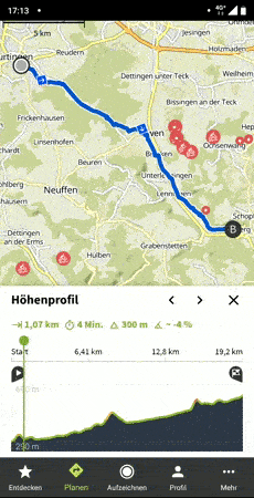
Then you will be shown additional useful information:
- Elevation profile of the planned route over time.
- The path type and the surface of the planned route.
With this information you can better estimate the difficulty of the route. You will also be informed where a particularly tricky climb may be waiting for you. Using DETAILS will show you this information in more detail.

Detailed view of the elevation profile, trail type and surface. Use the left and right arrows to switch through the views. On the detailed view you get an even better insight. komoot exactly test is worthwhile here in any case! The information displayed is interesting and offers a real added value to the route info.

You can swipe your finger over the graphic in the lower section of the screen. Additional information is then displayed on the map.
- Elevation profile: Hover your finger over the elevation profile. komoot shows exactly where the currently touched spot is.
- Path types: Tap one of the path types. Sections of this type of path are then highlighted on the map.
- Surfaces: Tap one of the surface types. Sections of this surface type are then highlighted on the map.
Practical tip – komoot experiences: Especially the detailed view of the altitude profile is very helpful. I use this function very often to get a better impression of the planned route. The legend can also be displayed when navigation is active. So you keep the overview.
komoot maps
How do komoot offline maps work? How good is the card quality and which cards are used? In the komoot test you can find out all the details about the komoot maps and the offline map download.
Card quality and which cards are used?
The display of the map is very good. You can clearly distinguish different paths from each other. Sometimes the line of the recommended route runs directly over a place name. Then you can hardly recognize the name. The font size on the map cannot be changed. In most cases, the writing can be seen very well. If not, you can quickly zoom in and out with a zoom gesture. Test komoot and you will quickly notice: Overall, the maps are of excellent quality and you can navigate with them excellently. So the minus points are complaining on a high level.
Which maps are used? komoot uses maps from the free OpenStreetMap Project (OSM). If you discover an error in the komoot map material, such as a missing street, then you can correct the error directly at OpenStreetMap. komoot retrieves the data from OSM in an interval between one week and one month. You can find more information about this on the komoot support page.

komoot also offers free map updates: You can conveniently download the updates directly via WLAN as soon as they are available. I already mentioned it above: komoot itself receives map updates from OSM at intervals of between one week and one month. So you should be able to count on regular map updates 😉
Komoot Offline Maps
You want to use offline maps with komoot, so you can navigate without an internet connection? This costs money at komoot. Either buy a region pack or the full world pack. Individual regions start at €4 and the world package costs a regular €30. The prices are one-time purchases.
Meanwhile, there is also komoot Premium as a subscription model. Most cyclists won’t need the Premium subscription and will be very happy with the world package one-time purchase. I myself have been on numerous bike tours in Germany and all over the world. The komoot world package has always been easily sufficient and komoot premium I have not missed so far.
This is how you buy a region pack or the full world pack:
- Tap on More in the main navigation
- Now a big banner komoot Maps appears directly and you can tap on manage your regions
You will then be taken to the menu shown below. Here you can buy single regions or directly the world package. To make regions available offline (map download) tap on a region and activate the switch Offline available. With the magnifying glass at the bottom right you can search for your desired region.

Use komoot offline on your smartphone
Is offline navigation possible with komoot? Answer: Offline navigation is possible but offline tour planning is not possible. In this section of the komoot manual you will find out what exactly you have to consider.
use komoot offline – route planner: To use the komoot route planner, you need an active internet connection. Unfortunately it is not possible to plan a tour offline.
komoot offline navigation: Komoot can make maps available offline. This saves data traffic on the road. You can download planned routes offline at komoot. You can then start a previously planned route even without an internet connection. The navigation also works completely offline.
This function saves data traffic but komoot cannot be used completely offline. So you need mobile radio or WLAN.
The full range of functions of the web application is also available to you with the komoot route planner on your smartphone. Important data such as duration, distance and altitude are also displayed in the route planner.

Bike tour with komoot: start navigation and record tour
There are several ways to start the bicycle navigation with komoot:
- The direct start of the komoot navigation you have already learned above: Select destination on the map or determine by address input. Then the komoot navigation goes off with the NAVIGATION button.
- You can also select an already planned tour from your profile. Your planned tours can be found here: Profile – Planned – select your tour here and tap NAVIGATION.
That was fast, wasn’t it? Already you can start cycling 😉
Do you want to navigate on the go without internet or save data volume? At home, activate the in the WLAN. offline available. switch. The data required for offline navigation is now downloaded to your smartphone.

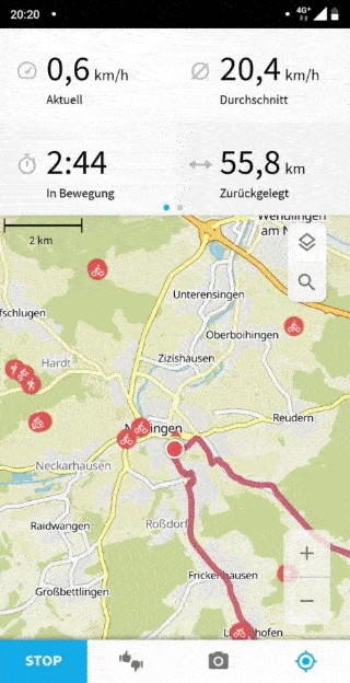
For bicycle navigation on tour, the map is displayed large in the middle. In addition, komoot supports you during navigation with the following hints:
- Visual turn-by-turn directions at the top of the screen (arrows and distance)
- Additional information at the top of the screen
- Voice announcements
Let’s take a close look at the functions and settings 😉
Visual turn-by-turn directions during komoot navigation
The arrows in the upper part of the screen are large and easy to read – really helpful. In the default settings, a large arrow clearly shows the direction of the next turn. In addition, the distance to the next turn is displayed.
With the arrow buttons forward and back, you can jump directly to the next turn. You can comfortably explore the route section ahead of you on the Navi route.

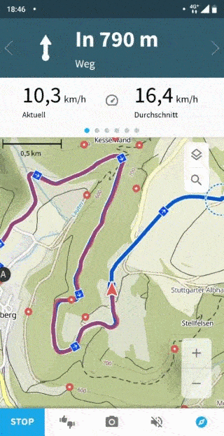
Additional information with komoot navigation
Directly below the turn-by-turn directions (arrows and distance), additional information is displayed in komoot navigation.
komoot shows you the following information:
- Speed: Current, Average, Maximum
- Distance: Distance traveled, distance remaining.
- Time: Time in motion, time remaining.
- Distance: Kilometers traveled
- Elevation meters: graphic altitude profile, current altitude, current gradient, covered altitude meters up, covered altitude meters down.
Swipe left or right to cycle through the information.
By tapping on it, the information is displayed large on the screen. The large display for the altitude profile is very helpful.
You can also display the additional information in an alternative view: Then more information is displayed on the screen at the same time.
Voice announcement for komoot navigation
I personally have the voice announcement activated most of the time, I also think it is very useful. Most of the time, however, you have to look at the display when you hear a voice announcement, because turns, for example in the forest, can often be confusing. If you only rely on the voice announcement, you will quickly take a wrong turn. A voice prompt is therefore an indication to look at the display now. On the display you get more detailed information and can turn accordingly. While komoot navigation is active, a loudspeaker icon appears at the bottom of the screen: Tap on it. Now you can make settings for the voice prompts. For example, set a notification tone instead of the voice prompt or mute komoot completely.
Shortly before a turn, the smartphone screen can also be switched on automatically.
When leaving the tour, the route is automatically rescheduled (can be switched on and off). The recalculation works very well and fast: Komoot does not ask you to simply turn around, but guides you back to a sensible point on your planned route in the direction of travel.
Once you have reached your goal, press and hold the STOP button. This completes the tour. Before the tour is saved, you will be asked a few questions: about the sport, about friends, if you want to upload photos and you can add highlights of the tour. Only after these questions you can save the tour in your own online tour diary. You will also receive a summary with the most important data about the tour. There are a few too many questions for my taste but that’s a matter of taste.
komoot GPX import to smartphone and computer
You can import an existing route in GPX format to komoot on the komoot smartphone app and on your computer. In the following section I will show you how to import a route to komoot.
komoot GPX import on PC
Is it possible to import GPX files from the internet or from friends? Yes, you can easily import a GPX file on your computer at komoot. On the screenshot you can see at a glance how it works:

These are the steps to import a route to komoot:
- Start komoot route planner
- click on the Plus icon in the upper right corner
- drag and drop the GPX file into the browser or click on the upload file button and then select it
Then komoot asks whether the file should be imported as a planned or made tour.
komoot can import the route of the original GPX file. On request komoot adapts the route of the GPX file to known paths. The corresponding query appears during the import process and is shown in the screenshot below:

When should I follow the original route? When you are sure that the imported GPX file was created reliably and meets your needs. For mountain bike tours through the terrain, this option is often necessary.
When should I adapt the route to known trails? When the quality of the GPX file is not guaranteed or when you want to adapt e.g. a MTB route to a gravelbike profile (cycling with gravel).
Click on Save Tour now to save the tour directly to your profile. With a click on Check details you can edit the tour of the GPX file with the komoot route planner. You can then use the komoot route planner to adapt the imported file to your individual preferences. You can also find out how the komoot route planner works in detail in this article (below).
komoot GPX import on the smartphone
komoot GPS import is also possible on the smartphone. You can select a GPX file on your smartphone and import it to komoot.
Either you save the tour in your profile. Then you can use the tour later or directly start the bike navigation with komoot.
Alternatively, you can import the tour into your profile and use it for further planning, i.e. customize the tour according to your wishes.
The screenshots show the komoot GPX import on the smartphone:

This is how the komoot GPX import works on the smartphone in detail:
- Change in the main navigation to Profile
- For tours, tap the + icon
- Import file (GPX, FIT or TCX). tap.

Now you can select the GPX file on your smartphone and start the import process. The tour is then available in your profile under „planned tours“.
You can customize the tour with the komoot route planner or start the bike navigation directly.
Durch meine ausführliche komoot Anleitung hast Du die App im Detail kennengelernt. Im folgenden Abschnitt erfährst alles über die Routenplanung von komoot. Danach kannst Du Deine nächste Radtour mit komoot planen. Fangen wir an, ganz einfach und Schritt für Schritt 😉
komoot GPX download on smartphone and computer
Komoot offers interfaces that are used by numerous GPS devices. You can also download the tours you have made as GPX files. A GPX import to komoot is also possible.
In this section you will learn how the following functions work:
- GPX Export on computer and smartphone
- GPX Import on computer and smartphone
- Explanation he wireless interfaces to Garmin, Wahoo and Sigma ROX bike computers.
komoot GPX download and export
The komoot GPS download (export) works both on the computer and on the smartphone. On the screenshots below you can see how to proceed.
Download GPX file: You can download a GPX file directly from the komoot website. This is a universal solution, because just about every GPS device can process GPX files. This means that you can also use your tours with GPS devices that do not have a komoot connection.
komoot GPX download on your computer
Tours that have already been planned can be found in your komoot profile. You can do this with Profile – Planned. You can select all planned tours directly from there.

Komoot GPX Download on your smartphone
The komoot GPX download also works on the smartphone. In the screenshots below you can see how it works. Go to: Profile – Planned (for tours) – select the desired tour – tap on the three dots in the upper right corner – select Export GPX file.

You can now copy the downloaded GPX file to your GPS bike navigation system via cable. Most of the time, however, using the GPX file is much more convenient. In the next section you will find out what options are available.
komoot interfaces to Garmin, Wahoo and Sigma
Most current GPS bike computers have komoot directly integrated. This is very convenient and you can download your tours directly to the GPS device wirelessly. Sometimes this is done directly on the GPS device and with other manufacturers the download is done via the smartphone app. I’m going to show you how this works for the most popular manufacturers:
Garmin Connect
The komoot Garmin Connect IQ app is available for all current Garmin Edge GPS bike navigation devices. The komoot Connect IQ app is also available for some outdoor GPS devices.
With the komoot app you can synchronize your Garmin GPS navigation system with komoot. Your planned routes are loaded from your komoot profile and can be downloaded directly. The whole thing is conveniently wireless via WLAN. The full functionality of Garmin Navigation is then available for the downloaded routes.
When you start the Garmin Connect IQ App for the first time, you have to log in once with your komoot profile. Then your credentials are stored in the app. Your planned tours can then be called up from your komoot profile and made available offline.

You want to know immediately how this works in detail? I’ll create an article for you soon with all the features of the Garmin Connect Conncet IQ app: explained simply and step by step (incl. video).
Reading tip: You can find more on this in the detailed Garmin Edge 830 field test.
Wahoo ELEMNT Series
The Wahoo Element comes from the factory already seamlessly equipped with a komoot interface. All you need is the Wahoo ELEMNT app on your smartphone. The setup is very simple and I can explain it to you in a few steps. This is to be done:
- Connect your Wahoo ELEMNT Navi to your Wahoo ELEMNT smartphone app via Bluetooth.
- Visit the following menus: Settings > WLAN > upload automatically.
- „Tap „All Apps
- Select Komoot and log in with your login data in the dialog that now appears.

All your routes planned in komoot are now automatically displayed in the Wahoo ELEMNT app. You can transfer the routes to your Wahoo ELEMNT bike computer via Wi-Fi. With just three simple steps in the Wahoo ELEMNT app, you can start bike navigation:
- „Tap „Choose a route
- Now all your routes saved with komoot appear. Tap on your desired route.
- Tippe auf den blauen Button „WÄHLEN SIE DIE ROUTE“, um die Route direkt per WLAN auf den Wahoo ELEMNT Fahrradcomputer zu übertragen. Dort kannst du die Navigation direkt starten – okay, dazu musst du noch eine Taste auf dem Wahoo ELEMNT drücken 😉 eigentlich sind es also vier Schritte.

Reading tip: You can learn more about this in the detailed Wahoo ELEMNT ROAM field test and in the Wahoo ELEMNT BOLT field test.
Simga ROX 12.0 Sport
The Sigma ROX 12.0 Sport has a komoot app installed directly on your bike computer. You can launch the app directly from the main menu. Then all you have to do is log in with your komoot credentials. Now you have access to all your routes planned with komoot. You can start the komoot navigation directly on the Sigma ROX 12.0.

Reading tip: You can find more on this in the detailed Sigma ROX 12.0 Sport field test.
Fitbit
komoot unfortunately does not have an interface to Fitbit. Neither Fitbit nor komoot offer a corresponding interface. On the official Fitbit forum, users have wanted a komoot Fitbit interface for some time but there is currently no solution for it.
As soon as there are news about komoot and Fitbit, you’ll get the news here 😉
Plan your next tour with the komoot route planner
Komoot is probably the most popular app for smartphone navigation. In this section you will learn how to plan your next bike tour with komoot. Simply on your smartphone, tablet or computer.
You want to plan a bike tour with komoot? You can also enter intermediate destinations when planning the route, which is then automatically adapted by komoot to your selected sport. Komoot also shows you a lot of useful information about your planned bike tour. For example, duration, distance, altitude uphill, altitude downhill, the nature of the path and a graphical altitude profile.
You can plan a bike tour with komoot on practically all devices on the computer in the browser or in the app on the smartphone or tablet.
The most comfortable way to use komoot is on your computer or laptop. Of course, route planning also works on the go on your smartphone or tablet. All created routes are saved in your komoot profile and you can change them on all devices at any time.

Komoot route planner on the computer
On komoot.de in the browser you can plan your bike tours comfortably. The komoot planning portal is one of the best bicycle route planners. You can use the komoot route planner exclusively for route creation without later navigation. Of course, the navigation with the komoot app or a GPS bike navigation system is particularly suitable.
komoot navigation with smartphone app: The planned routes are automatically and wirelessly synchronized with your komoot smartphone app. You can use the planned tours directly for bike navigation with the komoot app.
komoot Navigation with Garmin, Wahoo, Sigma etc.: You can also download planned routes directly via GPX file. The file can be easily transferred by cable to your GPS navigation device, e.g. from TEASI. Many bicycle navigation devices also have a komoot interface. For example, these are the popular devices from Garmin, Wahoo, Sigma and other navigation devices. With the interface, the planned tour is transmitted wirelessly to your GPS navigation system. I have already explained wireless synchronization in detail above.
Free route planning is super easy: Enter your start and finish points and choose your outdoor sport (cycling, mountain biking, gravel biking, road biking). Komoot immediately calculates a suitable route for your activity. Similar to Google Maps, you can fine-tune the route. Due to the simple operation, even beginners will immediately get along with the operation during the first komoot test:
- Click on the route and a waypoint is created
- Click the point and hold the mouse button down
- Hold down the mouse button and move the point to the desired path
Komoot will adjust the calculated route live. You can see the new route suggestion directly. The new route section meets your requirements?
- Release the mouse button and the intermediate point will be anchored at this position.
Super! Now you can plan the next section 😉

Practical tip: The screen on the left shows you path types and path conditions. Just move the mouse over it. The map will then show you which section of the route has this trail type or trail condition. A useful function!
With komoot you can do simple tours Outward only or round trips outward & return. You can find this function on the left side of the screen at . route. .
Watch out: For short tours komoot often plans the outward & return trip on the same route. Unfortunately, this turns out negative in the kommot test. Who would like to drive the same way there and back, please? The longer the planned route, the higher the chance of different outward & return routes and thus a varied tour! If there is a sensible route, komoot also plans different routes for the outward and return journey. Unfortunately, komoot often plans the almost identical outward and return route. In this case you can simply place your own waypoints on the map for the way back. Exactly as described above.

Du hast die Tour fertig geplant? Super 😊
- Click on the green button in the upper right corner. Save Tour.
- You can now give the tour a name and set it to private or non-private. The tour is now saved in your profile.
With the komoot app on your smartphone, you can start navigating right away. You know: The finished tour is automatically synchronized with your komoot app.
Alternatively, you can also transfer the tour to your navigation devices. The necessary steps can be found above in this komoot guide.
komoot route planner on the smartphone
Why should you plan a tour on the road with the komoot app? With komoot you can plan your next tour on the road and navigate immediately. Tour planning and bike navigation on one device!
Use the komoot route planner on your smartphone or tablet while on the road: With the app you can, for example, plan your next bike tour or tour stage in your tent or hotel room. The route planner in the komoot app has all the functions that you can also use in the browser. Of course, the operation on the small screen is not as pleasant as on the large computer or laptop screen.
Own komoot experiences: A multi-week tour I often plan in advance with the route planner on the computer. I then plan small changes to the route from time to time with the komoot app while on the road.
komoot route planner in the smartphone app: In the simplest form, you enter the start and destination point and tap the button. NAVIGATION. . The navigation is already started. Locations can be set by keyboard input. Alternatively, you can press and hold a location on the map. Now a menu will appear where you can Add ADD TO TOUR – AS A NEW DESTINATION. can choose.
Additional options in the komoot route planner in the app: Choose whether only the outward route or the route for the outward & return journey should be calculated.
You planned the route? Great. So you can adjust the calculated distance individually.
- Add waypoints
- Changing the order of waypoints
- Replace waypoints
- Delete waypoints
Immediately after you have made a change to the route, komoot recalculates the route and you see the result on the map. When you are satisfied, save the route or tap NAVIGATION to start.
komoot experiences
komoot is one of the most popular route planners for bike and outdoor navigation – and for good reason: the complete komoot universe is easy to access and very user-friendly. After only a few minutes of planning, the first draft for the bike tour is clicked together: Mostly with a very good result. The route planner only becomes sluggish for very complex tours with several thousand kilometres.
The interaction of the komoot platform is great: The website and the app have almost the same (large) range of functions. All changes made are visible at all times both on the website and in the smartphone app.
If the route is planned then the bike navigation can be started directly with the komoot app. Too bad the route planner doesn’t work offline. The navigation is clear and many interesting route information can be displayed. This makes komoot one of the best bike navigation apps. As an alternative to the app, it is also possible to export to a GPS bike navigator from e.g. Garmin, Wahoo or Sigma. If your device does not use a komoot interface, then the GPX file can be exported and copied to the GPS navigation device via cable.
In the free version komoot already offers a lot and you can use the app as long as you want for free. An upgrade is quickly worthwhile for intensive use: Offline navigation, voice announcements and the transfer of planned routes to a GPS navigation device are then possible. With a regular price of 30 euros, the komoot world package is also pleasantly inexpensive.
Conclusion of the komoot test
Good
✅ Immediately understandable and simple operation
✅ Excellent route quality
✅ many tour suggestions with high quality
✅ clear navigation
✅ Integration with current bicycle GPS navigation systems
✅ Available as an app and in the browser – perfectly integrated
✅ Low price: World map package for 30 EUR
Bad
❌ Route planner requires internet connection (navigation is possible offline)
❌ Focus is on the route planner and the navigation – no fitness functions
Conclusion – komoot route planner
Good
✅ Routenhighlights entdecken und Überblick verschaffen: Mit einem Fahrrad Routenplaner wie komoot hast Du den Überblick: Du weißt schon im Voraus wo sich besonders sehenswürdige Streckenabschnitte befinden. Wo Du es auf Schotter oder auf dem Trail richtig krachen lassen kannst, weißt Du auch 😉
✅ probably the best bike route planner: komoot is for me probably the best bike route planner – particularly easy to use and at the same time outstandingly powerful in terms of functionality. Thanks to the large number of users, a particularly large number of interesting places (POIs) are also marked on the map, so you can also discover interesting new stretches of road in your surroundings.
✅ Route planning on desktop and smartphone: Whether on the smartphone or on the desktop – with komoot you plan your bike tour especially fast. The tour is also included on all your devices. GPS Bike Navi available. The public routes in the Discover menu and the routes calculated by the system also range from usable to sometimes even excellent. These routes can then either be ridden directly or serve as a basis for further planning.
Bad
❌ no complete offline mode: An internet connection is required for route calculation. The navigation of already planned routes works completely offline.
❌ For very complex routes, e.g. routes with a thousand kilometers and more, the route planner becomes very sluggish.
komoot alternatives
OsmAnd
OsmAnd as komoot alternative: More extensive in the navigation functions than komoot. In addition, both the route planner and the navigation function completely offline. Voice navigation is also included, as well as maps from various sources. A real added value! But the operation is more complex and OsmAnd is not available for the computer.
For professionals, the komoot OsmAnd is a real komoot alternative. Many users will be more comfortable with komoot.
Google Maps
Google Maps as a komoot alternative is particularly suitable if you want to get from A to B quickly. When touring with a city or trekking bike, Google Maps provides good navigation services. Always provided you are moving on paved roads and not on trails. Google Maps has arguably the best POI search of any navi app and a pleasant voice prompt. Google Maps is unsuitable for sporty rides or training units, e.g. with a racing bike or MTB.
Learn more about Google Maps for Bike in the Overview of TOP 35 Bike Apps.
Strava
The largest sports social network as a komoot alternative. Strava is strong as a training diary and especially popular with road cyclists. However, Strava is out of the question as an outdoor navi app, because the route planner does not offer the scope of komoot and also the navigation only offers basic functions.
Learn more about Strava as a komoot alternative in the overview of TOP 35 cycling apps.
What do you think of komoot for bike navigation and as a route planner? Do you have any questions? Feel free to write me your comment.
Reading Tip: Learn more about The Best Biking Apps here on the blog. There I present you the best bike apps & bike travel apps vopr. The best apps from navigation, training, MTB, bike computers, transportation, accommodation, communication and etc.


